How To
-
1
Insert the NC Map Component
Identify the page Content Type you are working on and whether the NC Map will be placed into a Band or Tabs/Accordion.
Placed in Band
- On Landing Pages, Site Pages, or Catalogue Items, first insert a Band with 1 or 2 columns.
- Select the Add Component button.
Note: The NC Map is not an option in columns that are too small for the map to be readable (1/3 and 1/4 width).

The NC Map may only be placed in a column that is 1/2 width or larger. Placed in Tabs/Accordion
- On the How-To content type, Add Tabs/Accordion to the desired Step.
- Within the Tabs/Accordion Item, expand the Advanced Settings menu.
- Select the desired Sidebar, then select Add NC Map.
- First Sidebar components appear before any text or content within the Accordion.
- Second Sidebar components appear after any text or content within the Accordion.
-
2
Default Map Data
The Map Table automatically loads default values for all 100 counties in North Carolina. Default county values are:
- County- each county name (example, Alamance).
- Title- example
- URL- https://www.google.com
- Fill Color- Blue
Customizing Map Data
You have two options for customizing the default values:
- Map Table Online Interface (Instructions in Step 3)
- CSV File Upload (Instructions in Step 4)
AccordionTab/Accordion ItemsFirst SidebarWhen you have more information to share than will fit into the NC Map information box, think outside the box by linking to another page with more information. The NC Map component below links to a variety of other Content Types on the platform. Explore these creative solutions to spark your imagination!
-
3
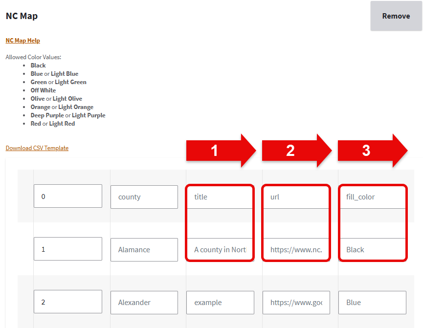
Customize using the Map Table Online Interface
The NC Map Table Online Interface displays automatically when the component is added to the page. Selecting the link to NC Map Help opens this tutorial in a new window. Allowed color values are listed for your convenience. This example walks through editing the default values for Alamance County:
- Under the Title column, the default value example is changed to A county in North Carolina
- Under the URL column, the default URL for the Google Search Engine is changed to the URL for NC.gov
- Under the Fill_color column, the default color Blue is changed to Black.
After making changes, Save the page.
Note: Remember that you must save the page often so you do not lose work. The CSV File Upload option may be best if you are creating a new NC Map or need to make many extensive changes.
 AccordionTab/Accordion Items
This is the resulting NC Map after editing the default values for Alamance County per Step 3.
-
4
Customize using a CSV File Upload
The NC Map Table Online Interface displays automatically when the component is added to the page. Selecting the link to NC Map Help opens this tutorial in a new window. Allowed color values are listed for your convenience. This example walks through editing the default values for Wayne County.
Download the CSV File Template
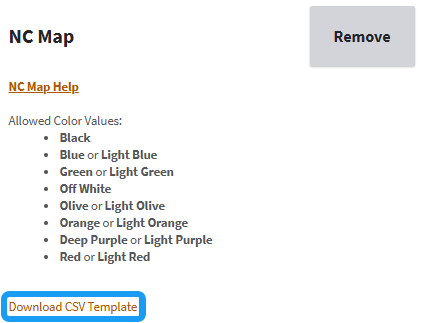
- Select the link to Download CSV Template.
- Find the downloaded file named nc_map_template.csv on your computer.
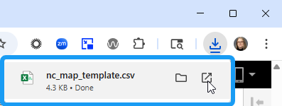
If you cannot find the template on your computer, check your Downloads folder. Open and Edit the CSV File
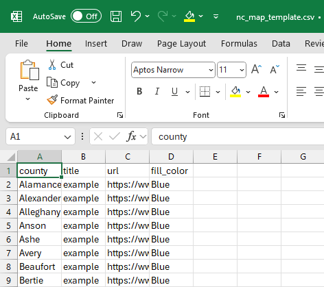
Columns are narrow by default. You can view the contents of a cell by selecting it and viewing the formula bar. - Open the CSV file with Microsoft Excel or a similar spreadsheet product to edit the values.
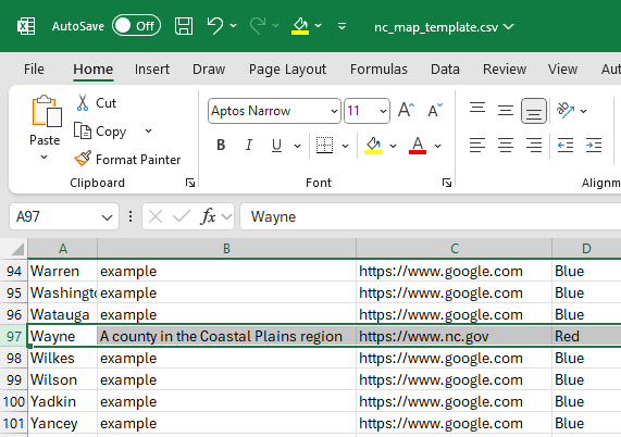
- Counties are listed alphabetically. Scroll to the bottom of the data to find Wayne County (97 out of 100).
- Under the Title column, the default value example is changed to A county in the Coastal Plains region
- Under the URL column, the default URL for the Google Search Engine is changed to the URL for NC.gov
- Under the Fill_color column, the default color Blue is changed to Red.
- Save the file.
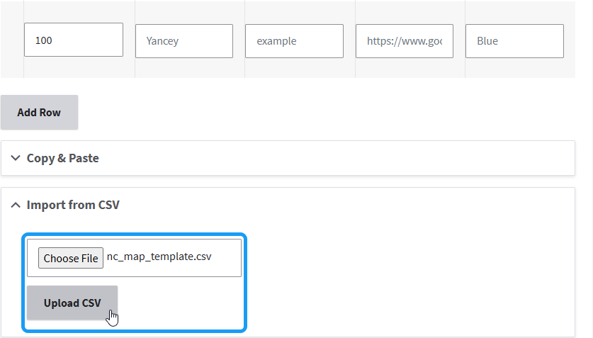
Upload the Edited CSV File
- Return to Digital Commons and scroll to the bottom of the NC Map Table Online Interface.
- After the County Data section, select to expand Import from CSV.
- Select Choose File.
- Locate and select the nc_map_template.csv on your computer.
- Select Open.
- Select Upload CSV and wait for the upload to complete.
- Save the page.
 AccordionTab/Accordion Items
This is the resulting NC Map after editing the default values for Wayne County per Step 4.
-
5
Color Options & Accessibility
Color Options
You can assign a color to each county. Allowable color values are:
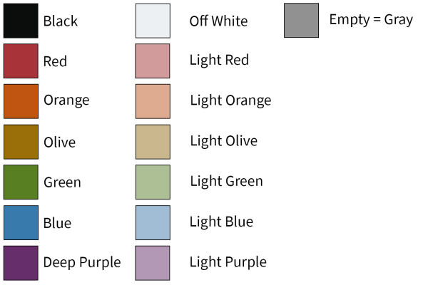
Samples of allowable color values. - Black
- Blue or Light Blue
- Green or Light Green
- Off White
- Olive or Light Olive
- Orange or Light Orange
- Deep Purple or Light Purple
- Red or Light Red
- Counties with empty Fill Color values appear gray.
Color Accessibility
Note that it is possible to select color combinations that are not accessible to users with various vision impairments. Be sure to follow Digital Accessibility best practices for color contrast and review your map with an accessibility checker.
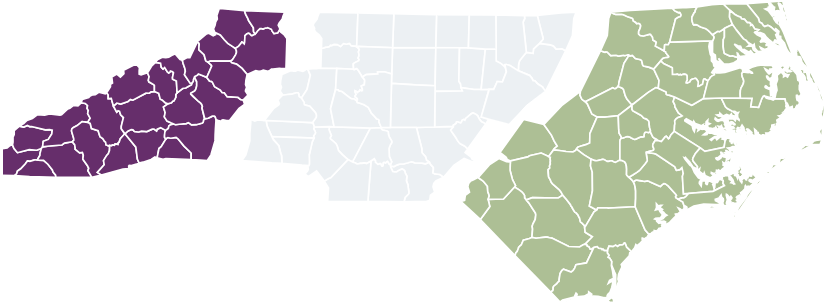
The images below depict a color combination (left) that is inaccessible to a person with color blindness (right.) You can use a browser extension, such as Colorblindly for Chrome, to simulate color blindness. This tool can help you choose a color combination that communicates with the widest possible audience.
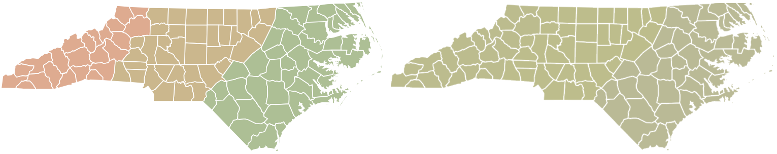
Left: Colors on an NC Map differentiate the Mountain, Piedmont, and Coastal Plains regions.
Right: The same NC Map as viewed by a person with deuteranopia, or red-green colorblindness. The regions are indistinguishable from one another.Digital Accessibility - Color Contrast
AccordionTab/Accordion ItemsFirst SidebarFirst Sidebar -
6
Advanced Customization
This example from the Department of Military and Veterans Affairs website goes above and beyond the basic text editing.
It includes an image of the seal for the United States Department of the Air Force and the name Seymour Johnson Air Force Base has bold formatting applied to make it stand out. The necessary HTML for the image was added in the Title cell for Wayne County. You can download the CSV file for this NC Map and study it to understand how it was done.
- If you want to include an image, you will need to upload it to your Media Library and copy the path to where it lives on Digital Commons. Be sure to provide Alternative Text when you upload any image.
- To learn more about HTML, visit W3C Schools for free tutorials.
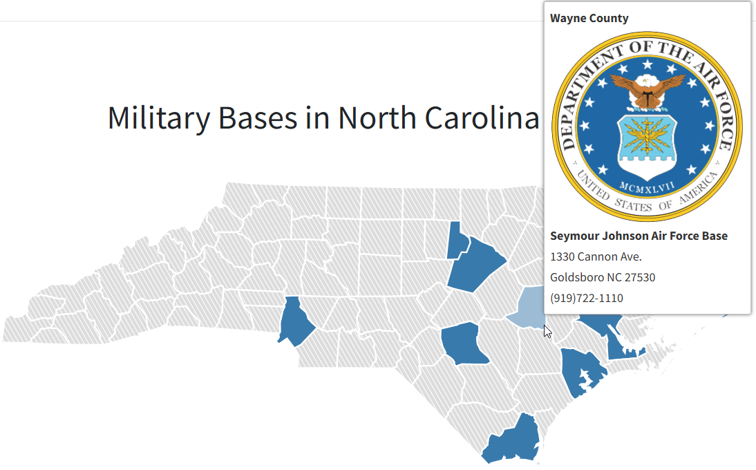
County
Wayne
Title
Seymour Johnson Air Force Base
URL
https://www.seymourjohnson.af.mil/
Fill Color
Blue
AccordionTab/Accordion Items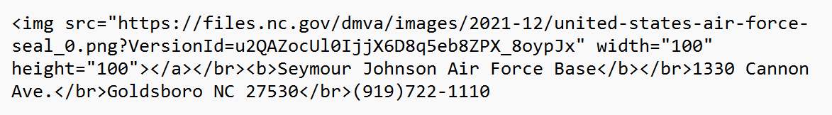
-
7
Accessibility
The NC Map can display visual information as text so that screen readers can make the information accessible to those with vision impairments.
- Select Text Version below the Map to view the textual listing.
- All 100 counties are listed. Counties with URL values are underlined (linked).
- The Title value appears below the link. Select the underlined link to open the desired URL.
- Select Interactive Map to return to the Map view.
Your Responsibility
If you create a Map where counties are grouped into regions, it is easiest to do this using color. However, any information conveyed with color must also be conveyed with text. For example, if Wake County is a certain color because it is a Piedmont county, specify "Piedmont county" as part of the text.
Exporting Map Data
The Map Data can be exported to a CSV file:
- To generate a CSV file, click the Export Map Data link below the Text Version button.
-
8
Mobile Behavior
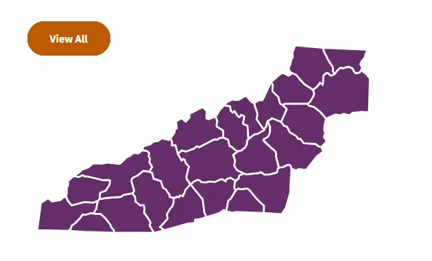
On mobile devices, the NC Map breaks apart by North Carolina's distinct geographical regions:
- Mountain (western region; deep purple)
- Piedmont (central region; off white)
- Coastal Plain (eastern region; light green)
The user taps the desired region to enlarge it and explore county content. Examples of the user experience for each region are provided below.
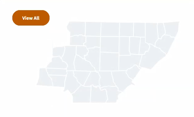
Screenshot of the map breaking into regions on a mobile device. AccordionTab/Accordion ItemsThis image displays the user experience when the Mountain region is selected. The user selects View All to return to the full map.
The map accommodates users on mobile devices by honing in on a smaller area of content by region. This image displays the user experience when the Piedmont region is selected. The user selects View All to return to the full map.
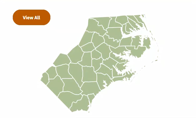
The map accommodates users on mobile devices by honing in on a smaller area of content by region. This image displays the user experience when the Coastal Plains region is selected. The user selects View All to return to the full map.
The map accommodates users on mobile devices by honing in on a smaller area of content by region. To experience in real-time how the NC Map is separated into regions on smaller viewports, view the example below on a mobile device:
- Tap the desired region to enlarge it and explore county content.
- Select View All to return to the full map.